
Sumba was our final island. In many ways it is the wild wild east of Indonesia. Like the wild wild west of yesteryears in the United States, Sumba is an arid, rocky, peripheral region with lots of horses and cows and a rough and tumble appraoch to life. Also unique are the many large 4X4 trucks that are needed to navigate the rough roads of the island.

Our united team of faculty and students first flew from Lombok to Bali for a connecting flight to Waingapu, Sumba. On the tarmac in Bali we took a photo of our inter-disciplinary team, before some of the team headed for some R & R on Flores and Komodo.
Love window seats.
Flying over flat and vulnerable Kuta, Bali.
Flying over the channel between Lembongan and Nusa Penida where we snorkeled.
Mt. Agung
The harbor of Lembar were where our ferry docked in Lombok.
Mt. Rinjani
Mt. Tambora on the island of Sumbawa. When it blew its top in 1815 is sent enough ash into the air to lower the temperature of the earth causing the year without summer that brought cold weather to much of the world resulting in crop failures, deaths and migrations (including the Joseph Smith family who left Vermont for New York).
The island of Komodo beneath the clouds.
Sumba
Sumba is unique in that is is not volcanic. It is an uplifted coral topped, limestone island. It also has a shorter rainy season and lower precipitation than most Indonesian islands. A recent project to boost agriculture output on Sumba is this large scale attempt to grind up the upper crust of coral dominant land so that sugar cane can be grown in large plantations.
North coast mangroves.
The Waingapu airport terminal.

Once in Waingapu we set up shop at the newest hotel in town--The Padadita Beach Hotel. It is indeed a beach hotel, but the beach is mostly a large tidal flat.


Mr. Cafe became our place for daily lunch,
A favorite for all of us were the avocado/chocolate smoothies. Sirsak (soursop) juice were also very tasty. Too bad mangoes weren't in season.

First afternoon a group of us did a walk-about through the main part of town, including the port, to check for tsunami evacuation signs and routes. We found nothing.

Bugis sailors.
The Bugis come from southern Sulawesi. They are a seafaring, and one-time pirating people. The Dutch feared their dominance of the sea lanes and purportedly often told their children to be good or the Bugis men (Boogymen) will get them. These days the Bugis have put down roots in many of the port towns of the archipelago.
Bugis schooners.
These Cats are lined up to be shipped back to Jakarta after chomping up all of the land in the large sugar cane project.
Unlike other cities we have worked in there is no clear up up and down in Waingapu. There are however lots of small ups and downs so it is hard to know were high ground is. With no signs or gathering places posted, we wondered if this mosque just a few hundred meters gradually up from the port would work as an evacuation point. Later mapping showed it was at a high enough elevation and its 2nd floor is wide open and can hold 1,500 people.
Red betel nut spittle decorates the streets and paths of Sumba.
As these boys clamored to be in my photo,
The guy in the back tipped to his right and sent a domino of bikes tumbling to the side with the end guy (laughing and embarrassed in yellow) tipping all the way off.
These boys playing on a sandy soccer pitch, got all excited when I asked them if they liked Messi or Ronaldo.
On the second day serendipity was in our favor. When members from our team went to the department of education to find out what schools we could present in, we were invited to come to a conference of Jr. High administrators from all of the East Sumba Regency and teach them. They liked what they heard and knew it was important for their school kids, particularly those along the coast. Soon our three days were filled up with teaching appointments.
The principals taking our tsunami survey.
That evening we took a beautiful drive though the surrounding country side. Here evacuation signs had been installed. Some led to hills others to rice paddies.
When I asked a Christian of Sumba what his favorite meat was--goat, chicken, beef or pork--all of which are found in Christian majority Sumba--he emphatically declared pork.
Locals chose not to have the hill be a disaster gathering point because of fears of landslides.
Instead they chose this farmstead in the rice fields, makes sense for some disasters but not tsunamis.
Further down the rural road this sign correctly pointed to the hills.
This strange monument was installed by a local Christian "gang" that seeks to establish a peaceful and loving environment. Cool efforts from a gang.
Our first school presentation was right on the coast about 6 kilometers NW from Waingapu.
The principal wanted everyone to hear, so the largest room in the school was cleared of its chairs and desks.
Everyone stood while they took our survey.
Bead of sweat.
Intently watching the documentary about the Aceh tsunami.
When the documentary showed a man climbing out of his collapsed building just wearing a white bath towel, they always laughed. They also laughed when a motorcycle tipped over in the oncoming water.
Afterwards I lead the evacuation drill.
This short 12 year old walked and ran the whole way. It was touching to see how well cared for and liked he was among his peers.
Down the coastal road for a few hundred meters.
Then turn left and head for the hills.
Some got worried that they wouldn't make it in the 20 minutes. No worries, the north side of Sumba has about 30 minutes to get to safety.
First arrivers--many of whom were rewarded with a souvenir bandana.

Post evacuation refreshment.
Later that afternoon we went to a traditional neighborhood in Waingapu where they make ikat cloth. Ikat means to tie. Strands of thread are tied/bound with dried long leaves into cool patterns and designs and then dyed with traditional colors or reds, blues (from indigo) and yellows which don't dye the areas that are tied.
Tieing.
Indigo plant in front and source of red coloring behind.
Weaving the died threads.
Traditional motifs include horses, cockatoos, butterflies, crocodiles, shrimp and lions.
We sat on the veranda of a traditional home and they showed us their ikats. I liked more than a few.
Loved this crocodile (a symbol of ancestors) one but it was beyond my budget.
Bought his one. The man holding it tied the patterns.
I bought the blue one too.
Modern day graves.
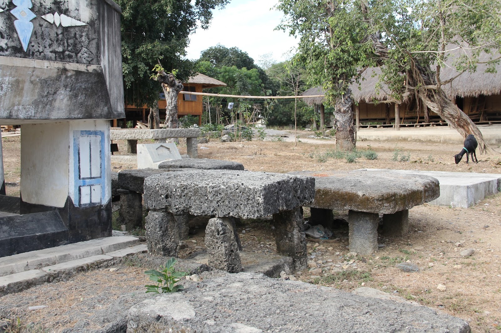
Older graves including the rock tables on the right, that were/are part of Sumba's animist tradition (Marapu). When asked I was told that most Christians on Sumba no longer make offerings to ancestors and spirits while others still combine the two belief systems. I've seen good Catholics on neighboring Flores sacrifice a live chick and chicken to a water goddess.
Betel nut chewers.The beetle nut is combined with alum and lime leaves to make a mildly narcotic chew that results in much red spit. Prolonged use stains the teeth red. Benefits included relief from tooth aches and a decrease in intestinal parasites.
She taught me about local beliefs. She is a practicing Protestant who no longer practices Marapu.
On Fridays these high school students start they day earlier than usual with a 7:00 am PE class.
We then drove an hour northwest ward to a junior high.
Lots of traditional houses along the way. Other homes have normal roofs. The walls may be made of thatched bamboo, wood planks, cinder block or cement.

We had to borrow the only projector in town from the high school. When asked in our survey and at the beginning of our presentation if the student thought there could be tsunamis in Sumba, almost all said no. When we showed them these two slides based on Dutch records (nine earthquakes since 1716 and 21 tsunamis since 1629), the students began to have a change of heart. They realized that their non-volcanic island could also be hit by earthquakes and tsunamis. Most in Sumba, including one of our hosts who teaches science at the local university, confessed that they didn't think Sumba was vulnerable.
Gliang, a geology graduate from UPN in Jogja, always does a great job teaching the students. He's knowledgeable, enthusiastic and uses humor.
Protestant churches on the drive home. There are more Catholics in the western half of the island. Sumba is a rare island for for a time the Dutch allowed missionaries from both Christian groups. Usually Catholics were assigned to work (hospitals, schools and later missionaries) on particular islands with the Prostestants assigned to other areas.

Wild East indeed.

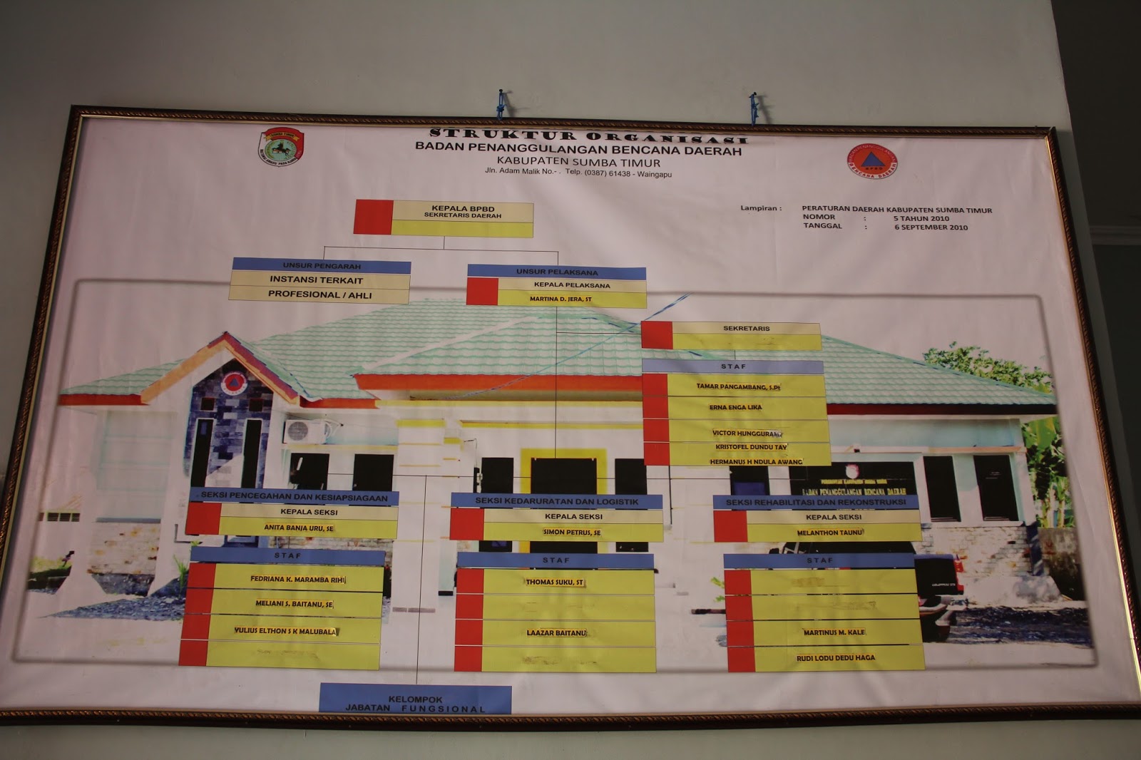
One afternoon we met with officials from the local Disaster Mitigation agency (BPBD). Interesting how many of its officials are women. We showed Anita, the director of the disaster preparedness section, a map that Gilang and BYU student Bryce made with help from me and others showing possible evacuation routes and gathering points.
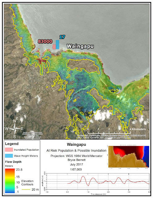
We used this inundation map for Waingapu to figure out safe places.
Saturday we taught 300 Jr High students at an Islamic Madrassah.
Everyone didn't fit in the room.

From my Instagram post: This morning in Waingapu on the island of Sumba, we made a tsunami
presentation to 300 students at the Islamic Jr. High. While watching a
short documentary about the 2004 tsunami in Aceh, we noticed the girl in
the center of the photo wiping tears from her eyes with the corner of
her hijab. As she watched first the devastation of the earth quake and
then the coming of the wave she mourned with those who mourn and
sorrowed for the hundreds of thousands who died. She and many other
students on Sumba now understand that their island is also susceptible
to such devastation.
Student participation at the end. Those who participated or correctly answered questions received a bandana. Any leftover bandanas were randomly distributed to students which always caused chaos--especially at this school.
By the end of the presentation, the girl with the tears (center bottom) was smiling again.
Final presentation at the Christian High School.
At the end I was introduced to the geography teacher.
That afternoon we went to the regional horse races. It reminded me of a rodeo.
Peanut and banana concessions.

Professor Sarah Hall and her student Amy from UVU attracted quite a gaggle of boys.
Four horses per heat and jockeys 10-12 years old.
Sunday morning I attended the Sumba Christian Church. Two hours of lots of singing--some familiar hymns (All Creatures of our God and King to start and God Be with You to end) and many not, two choir numbers and a solo, a baby baptism, scripture readings, sermon on Jacob's ladder and offerings.
The screens in the front posted lyrics to the hymns, scripture references and other images. A woman nicely led the whole meeting except for the main sermon by a man. The Centers of Strength approach to preaching the gospel in new and developing lands means that for now Mormon missionaries in Indonesia will continue to focus on Java--mostly Jakarta, and the Christian cities of Menado and Medan.
While four of us stayed int town to do presentations, two other teams headed to the southeast (removing cores of earth from a lake bed) and south central coasts of Sumba to look for tsunami deposits. They found several layers of sand, a layer of cinders from the Tambora eruption and large rocks rolled ashore by tsunamis.There is both written and geologic evidence of tsunamis in Sumba.
Ocean rocks deposited by tsunamis. Last three photo courtesy of Bryce Barrett.
For our final night we shared, in the hotel restaurant, our research and findings with local disaster officials.


 Post evacuation refreshment.


No comments:
Post a Comment