Tsunami inundation map posted in Pacitan. The colored areas are at risk from tsunamis. Blue arrows are evacuation routes.
The south Java coastal town of Pacitan was the most
impressive of the three cities we worked in in terms of local efforts and successes.
The local BPBD had set up 3-4 presentations every day to schools, community leaders
and scouts. Volunteers and staff from BPBD accompanied us to every visit, they
arranged for lunches along the way and they answered our many questions. Since
many of the schools had more than a few days advanced warning, we were welcomed
with singing, dancing, and gamelan playing. There were also snack boxes
(including an egg roll, some nuts, a cup of water) or plates of snacks presented
to us (boiled bananas, yams and peanuts, sticky rice and palm sugar treats
etc.) at most every stop. Along the way it was encouraging to see maps posted
of inundation areas and evacuation routes.
Our first day we visited the desa (village) of Sitomulyo an hour's drive east of Pacitan.
This village won a provincial award for its self reliance efforts in disaster mitigation. It was impressive to see local villagers doing as much as they could to protect themselves.
Presenting to village leaders.
Evacuation gathering place. Nice idea but it needs to be in a higher elevation.
The village is beyond cell phone coverage and is not hooked up to any early warning system so they rely on the old fashion method of hand pounded metal or wood alarms. This one is at an elementary school.
The main village alarm. There is a posted code in which different patterns of pounding mean tsunami, fire, robbery, murder, etc.
School girls practicing Javanese dancing as we arrive to do a presentation.
Evacuation drill.
Unfortunately the evacuation route "dead ends" at a lengthy and tall rock wall that school kids would have a hard time scaling. Plans are already inplace to install stairs here. Funding is the problem.
After a morning of presentations we were treated to a great rijstaffle (rice table). I loved the yellow fish curry in the center.
The view of the main mosque from our hotel roof.

Unlike Pangandaran, Pacitan has nearby hills for tsunami refuge.
That afternoon I went for a long walk through town from our hotel down to the beach.
Later that Saturday night, I went to the near-by alun-alun (city square) for a production of the Ramayana-using shawdow puppets and with a gamelan orchestra.
Sunday morning we taught 100 enthusiastic scout leaders of Service Brigades about tsunamis. They represented troops from all over town. Scouting is a required extra-curricular part of schooling in Indonesia.
Thees shirts were donated by LDS Charities In Indonesia. On the front they explain our 20/20/20 message. The only indication this is from an LDS charity is the angel Moroni, above the third 20, blowing a warning trumpet (for either tsunamis or the restored gospel). We had hoped to hand out a few of these shirts as gifts at every presentation but they were delayed in printing and shipping so the scouts of Pacitan all got their own shirt. I told them that they should wear these shirts when they go to alun-alun on Saturday nights to hangout with their friends and that they can then use the shirts as a way to teach others about tsunami preparedness.
Another provided lunch. The grilled fish was delicious.
On Sunday we headed out in the afternoon to an
isolated, beautiful beach where one of the graduate students had found large
slabs of coral that had washed up on shore in a past tsunami. Part of our team
had been trenching and auguring the past few days on this beach to find
evidence of past tsunami deposits. It was nice to finally get out and see where
our other half hung out.
Lantana growing wield everywhere.

Monday morning bright and early (7:30) we met with the Bupati (head of a Pacitan Regency) in the regency office.
We then gave a more detailed presentation to all of the heads of departments. Here they are showing great interest in maps our team map of areas that would be inundated by tsunamis based on depth (blue) and wave speed (red).
Here we are singing the Tsunami song for the Bupati. The main singer is Sarah White who served her mission in Indonesia, took my Indonesian class at BYU, now teaches the intro Indonesian classes at BYU and is now working on a linguistics MA at BYU. She was an invaluable member of the team who did much of the presentation oversight. video courtesy of UVU geology student and fellow explorer Jeremy Andreini
BYU Geology Professor Ron Harris--the mastermind behind this project and Carolus Prasetiyadi--UPN geology professor (left) presented shirts to the Bupati (tan shirt) and the assistant bupati.
As the oldest white guy in the group, I was often asked to represent us in the welcoming ceremonies. Here we are at an Islamic school.
Giga, one of our team's geology students from UPN in Jogja, teaching about tsunamis. The UPN students all did excellent and entertaining jobs teaching.
We always taught two songs--one about what to do in an earthquake and one about tsunami 20/20/20--if the earth shakes for 20 seconds, you have 20 minutes to evacuate to a height of 20 meters. Here we are singing about an earthquakes lasting 20 seconds.
We also presented at a private school--The Nature (alam) School. It was a very cool school: a large central courtyard garden taken care of by the school kids, recycling stations in classrooms, art lessons using recycled items, lessons in local dance and music, colorfully decorated walls, etc. In my next life (or in retirement) I would love to teach at this school.
Giving a beginning greeting to the students.
Singing the tsunami song.
Garbage recycled as planters.
"Let's plant trees."
Our last training of the day was to the manager, safety team and workers of a cigarette factory where 1,000 women make clove cigarettes.
Next day we presented at a junior high.
Then at a high school--the alma mater of former Indonesian president Yudhoyono (SBY). This also was an impressive school. We met the man on my right at the scout meeting on Sunday (his scout leader hat--he treated us to the fried fish lunch), the provincial leader's office on Monday (his main job) and at the school on Tuesday (he is a parent volunteer over fund raising). Earlier in the day he had recruited the school music leader to take our tsunami song and set it to a familiar gamelan tune. He and the music leader sang it for us and then the students sang it for us. Very cool

Our final presentation in Pacitan was our most encouraging. We met with the leaders of two villages--in the open air office of the village of Kembang (Flower). The village on Kembang was one of the first that BPBD worked with in 2013 to help in becoming tsunami prepared. After the survey and while most were hearing our presentation, the elected leader of the village put me on the back of his motor cycle to go see what they had done.
They had posted sings showing areas that would be flooded in a tsunami.
Signs posted in Javanese telling residents where to go in an evacuation.
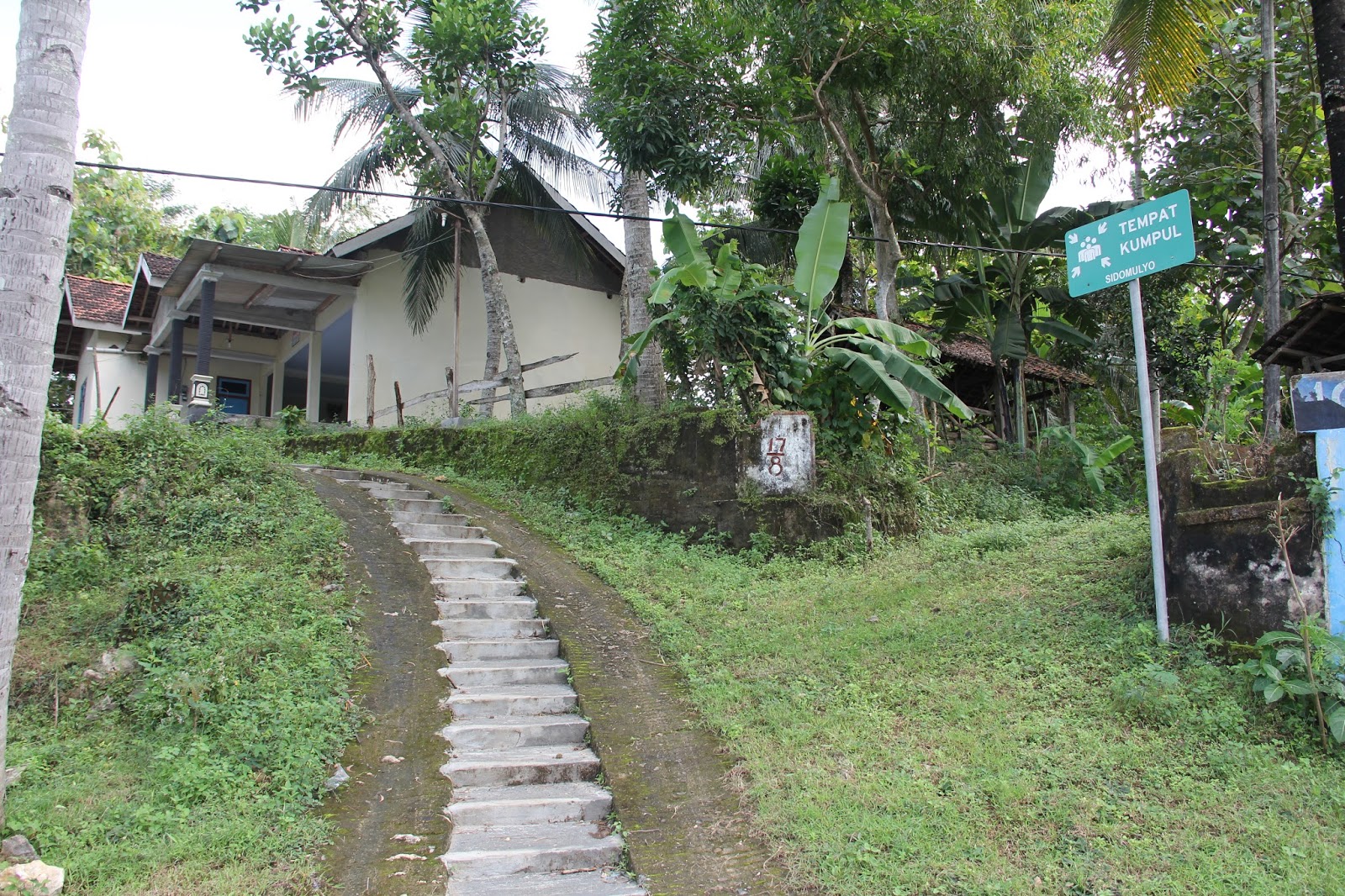
Posted signs of evacuation routes.
Widened and paved a path through the race paddies for easier evacuation.
Built two evacuation stairways up to higher ground.
The view of the village from one safe place.
The mayor of the village on my left and our BPBD host (Ratna) on my right. Good, friendly men.
Diana (volunteer) and Dianita (staff)--the two BPBP officials who made all of our arrangements in Pacitan. They accompanied us on all of our visits, provided information, arranged for snacks and lunches, and basically helped us meet over 1,000 people to talk about tsunamis awareness. They are impressive women who are leading out in their community.


 Unlike Pangandaran, Pacitan has nearby hills for tsunami refuge.


Chad I HAVE to steal your pics for my lecture on tsunamis in Indonesia! Pretty please!?! Did you put your blog ones in a separate folder or are they all together?
ReplyDelete