Sego lilies are the state flower of Utah. Sego is a Shoshonean word that is thought to mean "edible bulb"--an appropriate name since the small (marble to walnut size) bulbs were consumed by early Mormon pioneers to ward of hunger.
https://historytogo.utah.gov/sego-lily/
I grew up on these stories of the lifesaving bulbs, but I don't recall actually seeing a living sego lily until one day on a July 2008 hike to Stewart Falls above Sundance (above photo). Finding this lone sego lily bloom reminded me of an earlier time where finding flowers had become a quest.
During my dissertation research year in Nazareth I became enamored with the spectacular wildflowers of the Galilee. I even bought the above Wild Flowers of Israel poster to hang in my office to remind me of the many flowers I had discovered on walk abouts. I was surprised to learn that there was a rare Nazareth Iris (my favorite flower) with unique deep purple spots on its lower petals that only grew in the hills of the lower Galilee.
I did some sleuthing and found out the time when this iris bloomed. When the timing was right, I one day hiked out through the hills east of Upper Nazareth searching. I was delighted to find some blooming Nazareth iris and have slides to prove it (sadly buried in a box somewhere). Later when I returned to Utah, I joined by brothers for a mountain bike excursion in Logan Canyon. As we biked through mountain meadows I was surprised at the beauty of Utah's wildflowers--something I had barely noticed when younger but never much appreciated.
In 2010 when road tripping through the British Isles, we spent a night with Marie's cousin Shelly in Oxford. Next morning, she took us out to search for the famous blue bells. It didn't take very long, since Shelly knew where to look. We found a magnificent meadow full of the delicate flowers. Questing for national flower treasures started to become something I enjoyed.
During the COVID pandemic, the Bonneville Shoreline Trail that runs along the foothills above Springville and Provo (and much of the Wasatch Front) became my therapeutic friend. I delighted in watching the seasonal changes, particularly in terms of wildflower blooms. Two years ago in May, I happened upon hillsides of hundreds, if not thousands of sego lilies. Here are some photos from that late May two years ago:
Today I returned to the Bonneville Shoreline Trail (BST) and was happy to see that sego lilies are just starting to bloom. I decided to provide directions for anyone who wants a fun outing or an obtainable quest--to hike for an hour or two and to find sego lilies in the wild. Seeking and finding unique plants, animals or vistas can be a joyful, fulfilling experience.
Source: https://www.youtube.com/watch?v=kIPa4EJmPBw State of the BST (Bonneville Shoreline Trail)
My BYU geography colleague Brandon Plewe has been walking and documenting his travels along the length of the shoreline trail--which follows the shoreline of ancient Lake Bonneville. Last year he started in Payson and headed north. Episode 4 covers the length from Springville (Hobble Creek Canyon) to Provo (Slate Canyon) marked in orange and purple on this screen shot of the map Brandon made for his YouTube video. The Section of the tail where I found all of the sego lilies is the section from where the orange section ends (north/left), splits into the higher section (blue) and a lower section (purple) and then come together again just above the large gravel pit. Hiking that loop you will certainly see plenty of sego lilies, but only for a few weeks in late May and early June.
I started from my apartment on California avenue and walked up to Oregon Ave where there is public access to the trail. Hiking the whole loop from my apartment route takes about 2 hours. Starting from the center or south end requires only about one hour.
Here is the north access point on Oregon Avenue.
At the point where the access trail hits the BST, you can turn left/north and walk 30 minutes to Slate Canyon or you can turn right/south and head thirty minutes up and around the gravel pit.


When you get to this vantage point above the gravel pit the upper trail of the BST veers left/eastward up the mountain side. It's easy to miss.

Heading south, the lower trail veers right and the upper trail veers left.
Standing at the beginning/northernmost section of the upper trail.
On the left of the goggle earth photo you can see where the two trails spilt--yellow upper and red lower.
This is a steep section.
Deer carcass. It was a tough winter.
The view the other evening from the flat portion of the upper section of the trail looking west to the filling up East Bay of Utah Lake.

The photo above shows the area along the upper trail where the sego lilies are most plentiful and where all of the photos from two years ago were taken.
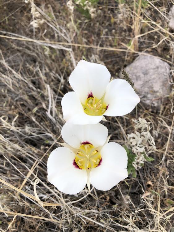
A lone bloom. They are just starting to open.
Several dozen blooms. On May 30th two years ago this section was covered with blooms.
The steep southward descent of the upper trail.
The trail winds a bit through some scrub oak then climbs sharply up where it rejoins the lower main portion of the BST.
Hang a left and head up to the mouth of Little Rock Canyon. From there you can descend to another foot access point on 800 East in Springville or continue southward along the trail towards Hobble Creek Canyon.
If you are coming from the south access point (see map below) on 800 East this is what the beginning of the upper trail looks like.
Little Rock Canyon
Looking down to the access point at the bend of 800 East. Notice the various sections of the BST heading south. This section of the trail(s) can be very confusing.
In previous years I would leave our home walking (lower left) and head up the hill to 800 East. For those driving, there is a place to park (lower right) at the bend of that uppermost road
The lower trail has much less elevation gain.
Notice highway 89 and the gravel road entrance (between the gravel pit and the lot of shipping containers) that leads up to a parking area and easy trail access.
The beginning of the lower trail has several branches. Eventually they merge into one path. Lower down is a gravel road that parallels the lower trail.
Brandon has been installing additional signs along the length of the trail to help navigation. They are most welcome in this confusing area.
Looking back south to the low ridge where the upper and lower trails merge and where the lower trail has several branches.
Before too long, I was surprised to see more sego lilies. This lower elevation means they are blossoming sooner than those on the higher trail. This section is marked on the map above.
Several bikers and runners passed me on the loop today. Mostly on the lower trail.
I wondered if it hit the power lines above?
At the mid section of the lower trail, Springville City has installed a trail access point (off of US 89) with parking. See map/photo above.
If you park here, you can head south/right to do the loop counterclockwise.
Or head left/north to start the loop going clockwise.
Today was the perfect temperature for a morning hike.
The lower trail is single track in the south section and double track gravel road to the north. Motor vehicles are prohibited along the whole trail.
From the rising lower trail at the southern edge of the gravel pit.
Back at the northern divide into upper and lower trails.
If this blog inspired you to get out and explore and if you found sego lilies for your first time, drop me a comment below. Also has anyone ever eaten a bulb? I haven't.


.jpg)