

Tuesday I took a road trip. First stop was the Layton Utah Mission office in Kaysville where I dropped off a Thanksgiving delivery (medicine, new pajamas, thank you notes, Advent candles and holder, raspberry jam and lots of fruit) for Hermana Emmett. I got to meet mission president Call who had all kinds of good things (naturally) to say about Sarah's service. That was a great stop.
I then drove west on I-80. First stop Grantsville for Gas and a Dr. Pepper.

I then headed north to Lakeside off of exit 62.


Air Force facilities


https://en.wikipedia.org/wiki/Lucin_Cutoff

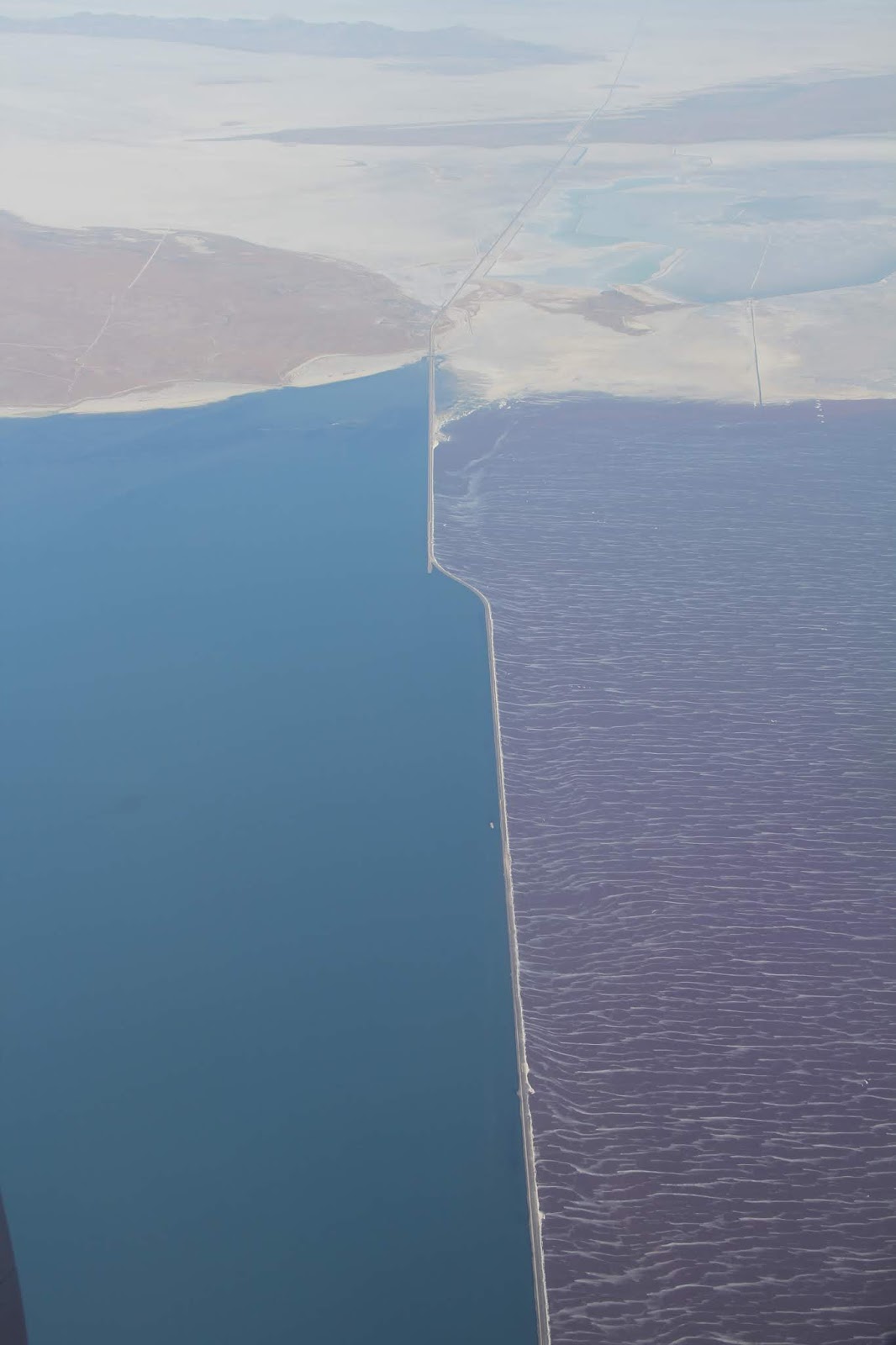
The causeway limits the flow of water between north and south which leads to color differences due to a salt loving bacteria found in the northern arm..
https://www.up.com/aboutup/community/inside_track/causeway-6-14-2016

https://www.usgs.gov/media/images/aerial-view-great-salt-lake-causeway

On a flight to Indonesia in July 2016 I took these three photos of the causeway. Lakeside is at the northern end of the Lakeside Mountain range (left center) right where the causeway meets land.


All that remains of the settlement is the cemetery which is lovingly cared for and which now houses facilities for a large Polynesian gathering on Memorial Day.


For more information on Iosepa check out these articles:
http://honolulumagazine.com/core/pagetools.php?pageid=6108&url=/honolulu-magazine/november-2008/remembering-iosepa/&mode=print
http://archive.sltrib.com/article.php?id=56607504&itype=CMSID
http://utahstories.com/2011/08/iosepa-mystery-utahs-hawaiian-pioneer-town/

Cemetery is lower center.


The central portion of the valley includes vast holdings of the privately owned Ensign Ranches.


In 1996 the Goshute tribe proposed using some of their reservation lands as a dump for nuclear materials (perhaps at this landfill site--from a photo from my drive two years ago). Governor Leavitt of Utah said that Goshutes could do what they wanted to on their sovereign lands, but the State of Utah would not allow the transporting of any nuclear materials along state roads (state highway 196 is the only way in and out) which nixed the project. That was a curious reaction given the fact that Goshute land is surrounded by federal and private facilities dealing with hazardous materials.

For more about Skull Valley and the battle over nuclear waste read this interesting article (with accompanying map, above) from Outside Magazine: https://www.outsideonline.com/1887871/valley-shadow
From the south end of Skull Valley I then headed east along the old Lincoln Highway (199) up an over the Stnasbury Mts to Rush Valley then south through Vernon, east through Eureka and finally home. A great day.
No comments:
Post a Comment