Tsunami inundation map of Kuta Lombok

We sailed to Lombok on a four hour ferry that departed from the Bali port of Padangbai.
Mt. Agung peeking above the clouds.
Mt. Agung (left) above the clouds of Bali from the middle of the Lombok Strait. This strait marks the Wallace Line--a biogeographical line that demarcates the divide between the Asia flora and fauna from Bali westward and Australia flora and fauna from Lombok eastward.
SW peninsula of Lombok
Entering Lembar Bay
First day in Kuta on the south shore of Lombok we walked the town mapping and evaluating evacuation signs and gathering points. It was a mess. We soon found out that just a few dozen yards down the street to the east from our hotel was a hillside perfect for a tsunami evacuation, but all of the signs on this street and in other parts of town pointed away from the life saving hills and towards gathering points in the city. The local logic is that it is best to gather first and then proceed to safe places with the help of emergency folks and magically provided transportation. With only 20 minutes to get to safety gathering first is not a good plan.
A sign pointing away from the hill telling people to gather at the elementary school a few hundred yards further into the very vulnerable town.
On the hillside we met this happy fellow. When we asked about the signs to gather at the school he just laughed and indicated that that was a crazy idea and that climbing the mountain was the way to save oneself. Throughout our week in Kuta we found that in spite of the crazy signage, most everyone in town knows to head for the hills.
The man in jeans built his house on the hill after the Aceh tsunami. He wanted to live in a safe place for his family.
The house on the hill.
The proposed gathering place (Tempat kumpul)--an elementary school.
This sign at the main intersection of town points to the main mosque as a gathering place.
The main mosque
The Mayor's office is also a gathering place. The orange sign in front of this gathering place points back to the mosque. All very confusing.
This animated seller of antiques whose shop is across from the Mayor's office readily admitted that he wouldn't gather, he would straight away head for the hills.
At the east end of town we ventured beyond the fourth gathering point (also in the flat tsunami inundation zone) and found several paths up the hills that would make good evacuation routes.
The view from one such proposed evacuation gathering place.

We don't know who excavated a road up the hill and flattened the hill top, but it makes for a good evacuation route and safe gathering place.
We gathered the data and then Bryce made this map. We hope to use it to get local officials to rethink their sign methodology. None of the signs lead to the hills.
A new great mosque in the works. Named after the the local goddess of the sea (Mandalika).
Kuta Lombok Beach
This evacuation sign pointed right in to a beach cafe.
Four signs by the beach pointing to the mosque and the mayor's office.
Presentation at SMP Negri 1 (Jr. High) in Mataram--the island's main city. Pak Pras from UPN is teaching about tsunamis in Indonesia.
Professor Sarah Hall (light blue) from UVU is in charge of surveying people to assess tsunami awareness.
"Of course, smoking speeds up death"
Tsunami inundation map of Mataram.

Ampenan Beach is the port of Mataram.
It has a sign with quotes from thee religious texts of Islam, Christianity and Hinduism exhorting people to not delay preparing for natural disasters because we never know when they will strike.

I was happily surprised to be greeted with such a great view across the Lombok Strait to Bali and Mt Agung.
Evacuation sign leading inland from the port. No mountains anywhere near, just distance from the sea. Second stories of the schools we visited would be safe places.
Chinese temple. In the past there have been anti-Chinese riots in Lombok and in December 1999 there were Christian-Muslim conflicts. The island is mostly Muslim, but there are also Chinese, Christian and Balinese Hindu minorities.
Back in Kuta we visited the Novotel to see if it too (like the Novotel in Bali) had tsunami evacuation preparations. At the direction of its parent company, the hotel had a third story gathering point and printed information about natural disasters in every hotel room. Many more hotels need to follow Novotel's example.
The rocky outcrop looks like a safe gaterhing point, but it would be covered in a strong tsunami. It would also be hard to safely gather many people on it sharp peak.
Instead guests gathered on the third floor or in the parking lot will be lead to the safety of distant hills.
The escape route.
Survey taking in Mataram High School.
The red on the map (made by BYU student Bryce Barrett) shows the inundation area for Mataram. Luckily this school is several kilometers inland and beyond the reach of what the tsunami models show.
Mataram's main mosque.


A candidate for governor.

Off the northwest coast of Lombok are three small islands (Gili) that are prime tourist destinations. Pemenang is the small port city where tourists can catch small boat taxis to the islands. Five years ago the national disaster mitigation agency (BNPD) built this Temporary Evacuation Building (TES) in the center of the town. Similar structures have been built in other tsunami prone areas including Pangandaran that we visited last year and Tanjung Benoa in Bali. The unusual thing about this TES is that it is in such a sparsely populated place. Locals suspect that there was some sort of corruption or collusion involved with the building of this TES.


The lower three stories are open to the waves. It is used as a badminton court.

In spite of the odd location and the questionable motives, locals have decided to embrace the structure and make it their own. To draw people to the building so that they know to evacuate here and to keep it from being vandalized, locals have organized artists to come and decorate the structure with fun murals. Also, once a year the structure hosts part of an annual cultural/art festival. The above mural encourages people not to panic, to go up here and to help each other.

Ducks draw people up the ramps.
Be careful (Onyak-onyak=hati-hati). Stay calm.
Together we our strong. The lord be with us.

The mural made to look like the base of the town mosque.
Stay together. Don't forget to be happy.

Umbrella provided before being rolled up (by the waves).
TES in this this mural stands for Taman (park) Evakuasi (evacuation) Seniman (artists). Artists evacuation park.
Man standing (floating) on an avocado.
Locals boys using the building to run laps up and down and then for push ups and sit ups.
Pak Pras talking with some of the local disaster mitigation officials and the founders of the mural project and art festival.

Gili islands in the distance.
Driving back to Kuta late that day we were blessed with a rare view of Mt. Rinjani the second tallest volcano in Indonesia.
Presentation at the Islamic Jr. High of Kuta.

Then we held an evacuation drill. Down the portico.

Out the back gate of the school. Across a yard. Down a country road and then up a hill where cows were grazing.
It was a great simulation. All made it to safety in less than 20 minutes.
Large wooden cow bells.
Ron Harris (in white), a geology professor at BYU, is the mastermind behind this multi-school, multi-disciplinary tsunami project.

Our Sunday outing was north to the southern edge of Rinjani National park where we hiked up to the beautiful sweet orange water falls.
A Javanese man from Mataram who comes to the falls every other week is taking a restorative shower in the fall.
BYU and UVU students and professors.
Top of the falls.
Bursts of red amidst the green.
On the way down I picked up garbage. Apparently not all Indonesians heed this admonition to not litter.
View from where we stopped for a late lunch.

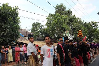
Driving back to Kuta we passed several wedding processions and a circumcision procession. The narrow streets turned into one lane traffic slow downs.
Celebrating a circumcision
Passing bride on the way to greet her parents in their home. This was out the driver's, open widow.
Wedding parade musicians.
Last day in Kuta. Presentation at Elementary School 2
Gilang using flip flops to teach about colliding plates buckling and causing a tsunami.
Playing a chutes and ladders game with a disaster mitigation emphasis.
We left the school (which is a designated gathering place) and headed for the hills. All of the students knew they should go to the hills. It was a 200 yard run.
The PE teacher came along.
Up the hill we visited on the first day here.
We did it in about 5 minutes.
Bandanas are given out as a reminder of our 20/20/20 mantra and as a game of chutes and ladders (ladders and snakes in Indonesia).
The view from what would be a great tsunami evacuation gathering place.
PE teacher and students beneath the sign that points people the wrong way.
Sarah Hall handing out bandanas.

Elementary School 1.
With the headmaster (left) and sixth grade teacher.
Papaya blossoms.
Man harvesting ants to feed to birds.
The pole punches ant nests high in the tree and then the ants drop into the basket.
Bottles of benzine--gas for passing motorcycles.
We walked from our hotel on the coast up to this excellent view of Kuta from the northwest.


No comments:
Post a Comment