Sunday, March 7, 2010

Abu Ghosh and beyond

For our Sunday outing we traveled to Abu Ghosh--an Israeli Arab town a few miles west of Jerusalem. It is the site of Biblical Kiriath Yearim. It has two Christian churches (both of which were closed on Sunday?) A Crusader era church is in the lower left. This town overlooks the main road from the coast up to Jerusalem. During the 40s many Arab villages along this road would attack convoys carrying supplies to the Jews of Jerusalem. These Arab villages also played an important role in the battles of 1948. Abu Ghosh was unique in that its residents remained neutral which at the end of the war left them in good standing as new citizens of Israel.

The hilltop church commemorates the place where the Ark of the Covenant resided after the Philistines returned it to Beit Shemesh and until David moved it to Jerusalem. Notice the Dome of the Rock decoration above the second story entrance to the home. It has become not only a symbol of religious affiliation, but also an iconographic symbol among Israeli Arabs that proclaims their identity as Palestinians too. Many Muslim-Israeli-Palestinian-Arab homes in Nazareth also prominently display the Dome of the Rock above their doors (see my book Beyond the Basilica for a map showing all the homes with this marking).
On the outskirts of town is the Elvis dinner--the dream of an Abu Ghosh native who as an immigrant to the U.S. won the lotto in Chicago. With those earnings he decided to come back home and help provide jobs for his fellow Israeli Arabs. He is a big Elvis fan and so this is his shrine to the king.
We checked out the menu--burgers, fries and other diner fair--but no prices were listed and it was still not yet lunch time so we bought a post card instead.
Sarah and I both got one. Pretty humorous I think. We then headed back into Abu Ghosh for some famous hummus (not the best tasting we've had) at one of several restaurants claiming to be the original Abu Shukri's hummus shop. Last fall the restaurateurs of Abu Ghosh prepared the largest hummus plate (actually a large satellite dish) in the world. The size far surpassed a similar attempt in Lebanon which was good enough to now be listed in the Guinness Book of World Records.
We then visited the Castel National Park. It is a commanding hill top the overlooks the southern side of the very vulnerable road up to Jerusalem.
In the 1948 war Jews and Arabs fought to control this strategic site. Jewish forces almost took it, but then Arab reinforcements saved the day. In the battle the Arab military leader (Husseini) was killed. The victorious Arabs returned to Jerusalem for his funeral and Jewish fighters were then able to claim the hill. We had fun exploring the battlements and bunkers--Will and his parents got to explore them all a second time as we went back to find his favorite red Batman hat that somehow fell off in one of the dark bunkers (good thing I had a camera flash to lighten up the dark).
We all enjoyed the spring-like weather and being out and about.
A relief map showing the road from Jerusalem (bottom) down to the coast. Arab villages controlled the heights all along the route. Castel is the flat topped, highest hill on the third left panel from the bottom.
The opposite view of the road going up to Jerusalem. The main road goes to the left. When it proved impassable, Jews built the "Burma Road" which branches off to the right and circumvented a dangerous part of the road. (for a good book about the battle for the road up to Jerusalem check out Oh Jerusalem by Dominique Lapierre and Larry Collins)
The view east from the summit of Castel. The hill in the center of the photo is now a huge Jewish cemetery on the western outskirts of Jerusalem--which you can see on the horizon. You can see the main road up to Jerusalem ringing that hill on the left and then again at the foot of Castel.
The view west with Abu Ghosh in the distance. The current road is cut to the south of town, but the 48 road skirted the town to the east.
We then drove back roads into town with a stop at this curious park and play structure. It is called Mifletzet (monster).

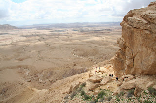
Earlier in the week I traveled to Makhtesh Ramon in the Negev desert. There the faculty enjoyed a hike up the side of the tectonic crater on an old Nabatean trade route linking Petra with Avdat and Gaza.
We then stopped in the Wilderness of Zin (where the wandering Israelites spent most of their 40 years) near Ben Gurion's inspired town of Sede Boker. Rainwater from storms earlier in the week made this usually inhospitable locale quite pleasant.

Amazingly the faculty agreed to me taking a jump photo of them. Classic

2 comments:

  1. I love the photos of the Holy Land. Thanks, Chad. Very strange monster. I seem to remember a similar one in Jordan at a restaurant Matt took us to when we were there.

    ReplyDelete
  2. Sounds like a day well spent. It is good you have been able to document all of your trips on the Blog so you wil have a record of them to remember. We are also glad you found Will's favorite hat!

    ReplyDelete