
Thursday and Friday was Fall Break for the kids and Marie, but unfortunately not for me. Thursday I did play hooky so I could go see the movie Pan with the kids. Then Friday after my two morning classes, Joel, Will and I headed south for an adventure. Sarah had her last ACT prep class on Saturday morning and so she and Marie stayed home (a movie night and shopping on Friday kept them entertained). Our destination was Nine Mile Canyon up the road from Price and Wellington Utah. It was a slice of Utah, I had not yet seen. The canyon has no public campgrounds and most of the valley is privately owned by ranchers. We camped at Nine Mile Campground--part of one of the private ranches. Most of our camping in recent years has been with the scouts and Young Men in the ward with their well outfitted camp trailer with its gas stoves and dutch ovens and with their inclination to cook delicious dinners and breakfasts. I'm not that guy. We went minimalist. Subway/Wendy's sandwiches to-go from Price for dinner, cold cereal and orange juice for breakfast and bagels, carrots, apples, and Marie's delicious zucchini bread for lunch.


After our no-cook, no-clean-up dinner we had time to go out exploring. Will balked at any mention of a hike for fall break, so we went for a "leisurely stroll" that he really liked.


We found three deer grazing on the stubble of an alfalfa field that we followed up into the hills. They kept an eye on us but didn't seem too worried. It is deer hunt season and I'm hoping they knew that they were safe on the private lands of the ranch and from the gunless/huntless Emmetts.


Hiking down we saw eight more dear, enjoying an alfalfa dinner. One was always on the watch.

We brought globe willow logs from home for our camp fire and s'mores.

Joel's artistic image of our campfire.

The boys slept in the 2 1/2 man tent and I slept outside on an air mattress with extra warmth from a Norda Emmett quilt. Will was a little worried for my safety at first. A flapping tent flap also worried him, but Joel came to the rescue with an explanation of what the noise was and letting Will listen to some calming music on his i-pod. Will was first up at 7:00 am. It was mostly dark, but we soon got a fire going by blowing on the remnant of last night's coals.

Part of the reason I chose Nine Mile Canyon was because an approaching storm was coming in Friday from the southwest and this more eastern part of Utah would not get rain until Saturday afternoon. We headed up the sunny canyon (most likely named by one of John Wesley Powell's surveyors when they explored and mapped the Green River, into which Nine Mile Creek flows.) Luckily the road was all paved a few years ago to cut down on increasing dust from all of the natural gas mining trucks transiting the canyon. We were armed with a long list of mile markers for Fremont Indian petroglyph sites. Some were easier to spot than others. I knew interest would be short lived so I pre-selected what I thought would be most interesting. First stop was the Tug-of-war.


 Rasmussen Cave.
It is privately owned as noted by this sign painted (over a petroglyph!) by the owner.


I mistakenly told Will we were going to hike up to a Fremont village which was his cue to start complaining. It took about 10 minutes to hike up to this rock covering a livable cave with multiple entrances. Fremont Indians lived in the valley until about 1200 AD.


Below were fertile lands of the creek-fed valley. Granaries were located along the cliffs, but they were one thing we never could see.


One of the few marked petroglyphs. This one is the most famous and it sits on Utah Educational Trust land. The state is covered with these square mile plots (marked in blue on government maps) which were established as part of the township and range system to make sure that every settlement had land for schools. Currently, mining, grazing and logging revenues from these plots help pay for education in Utah.


How have I never been here before? So much exploring still to do.


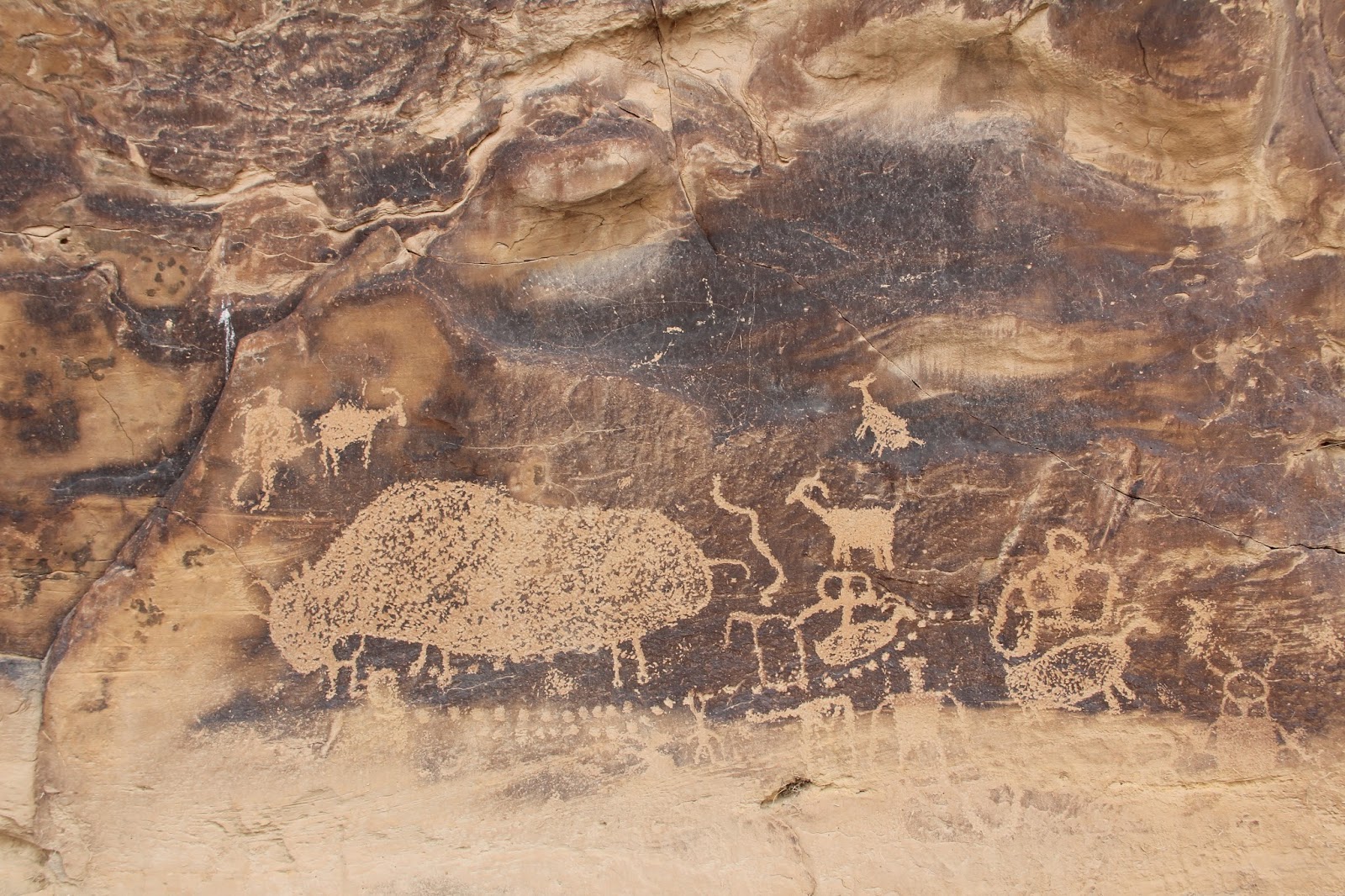
 Pregnant Buffalo


Our last stop was to see the many interesting panels accessed via a short stroll (not hike) at the entrance to Daddy Canyon. Who knows what these creative ancient Americans were trying to say. I have my own ideas.


We then headed north via Gates Canyon along a winding dirt road that eventually connected with US 40 near Myton that took us west back home.

The upper reaches of Gates Canyon and out into the Uinta Basin were dotted with natural gas pumps.


Alfalfa irrigated with water channeled via canal from the Duchesne River--which flows into the Green River which flows into the Colorado River. Foothills of the Uinta Mountains in the distance. It rained the last hour or our afternoon drive home. A grand outing.
No comments:
Post a Comment