We started out our Memorial Day by exploring Green River to learn about how a town survives in such a place. Green River started as a place to ferry across the river and then blossomed as a supply station for the railroad. Agriculture, including its famous melons, nearby mining and tourism are part of the current mix.


A few weeks ago I read in the newspaper that Green River's century old Tusher diversion dam had been repaired from flooding and also adjusted to allow downstream flow of small water craft and upstream movement of fish. My curiosity was piqued so off we went north along Long Street. Six miles north of town we found the low rising diversion dam with its center spill way for boats and its irrigation canals siphoning off water along both banks.


 The diversion dam and the beginning of the west bank canal.
 Looking downstream.


 Irrigated fields with Green Rive water. The first crop of alfalfa was already being bailed on some fields.
For photos of Joel's canoe trip down the Green River from Green River go here: http://beitemmett.blogspot.com/2013/08/canoeing-green-river.html
 We then drove southwestward into the San Rafael Swell to the wonderful Goblin Valley State Park with its fantasmic hoodoos.
 It is nature's best playground.

Two years ago some over zealous scout leaders toppled a hoodoo like this and then posted the video on Youtube. They took great joy in their feat and only later came up with the excuse that they toppled it to prevent it from tipping over and injuring someone. Idiots.


 Sarah had as much fun exploring as the boys and wondered why this is a destination for young men groups but not young women groups.
 Prepared to launch.
 Marie's one ascent (via a back-side ramp).


 Strong enough to hold tiny Sarah, but could it hold the whole family?

The back more hidden part of the valley. Joel had fun playing capture the flag here on a young men's campout a few years ago.


Stopped for a picnic lunch in the limited shade in an LDS Church parking lot in Hanksville. New church and old church face each other kitty corner.
 Interesting street name.
 The original rock church of Hanksville.
The drive from Hanksville to Capitol Reef has amazing rock colors of whites, greys, purples, pinks and reds--some of which looked tie dyed.

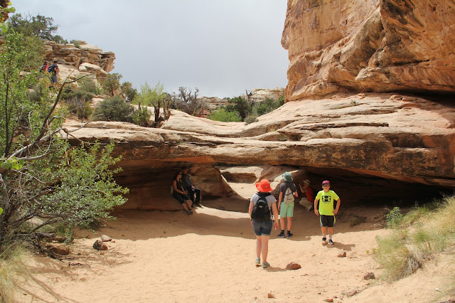 Our first stop was to hike up to Hickman Arch. This small bridge is not it.

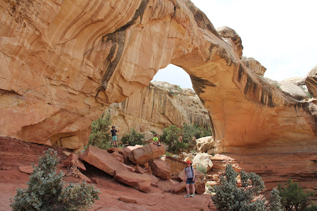
 Hickman Arch


 Cliff side granary built by the Fremont peoples.


Capitol Dome lends its name to the park as do the rock reefs that are prohibitive to movement just as ocean reefs inhibit ships from reaching islands.
 Fremont rock art.
 Desert varnish
 Milk weed--happy to see it growing for monarch butterflies to use to metamorphize.


One room school, chapel and community center for the Mormon pioneers who settled the well watered valley. They named their town Fruita. The National Park Service still maintains their orchards that were finally abandoned in the 1940s.


Fruit pies for an afternoon snack on the lawn of the Gifford Farm House. Peach and mixed berry pies for the kids.
 Rhubarb/strawberry for me. Yum.
 Drove the scenic drive southward.
 Ventured up Capitol Gorge. The Golden Throne loomed above. It is reminiscent of Zion's Great White Throne. Sarah then drove us out of the park to nearby Torrey.

 We ended the day with spectacular views from Sunset Point.


We all agreed that Capitol Reef is a beautiful, accessible, worth-the-visit park. It certainly deserves to be one of Utah's Big Five. For dinner we had delicious hamburgers and fries at Slackers in Torrey. We got back to our hotel in time for the boys to watch the Golden State Warriors win the conference championship and for me to go gas up and wash our sandy car in nearby Bicknell. Another great day. Glad we are not doing this all on a cloudless August day.
For photos of a previous trip to Capitol Reef (with a paleontologist) go here: http://beitemmett.blogspot.com/2014/03/capitol-reef_23.html


A few weeks ago I read in the newspaper that Green River's century old Tusher diversion dam had been repaired from flooding and also adjusted to allow downstream flow of small water craft and upstream movement of fish. My curiosity was piqued so off we went north along Long Street. Six miles north of town we found the low rising diversion dam with its center spill way for boats and its irrigation canals siphoning off water along both banks.


For photos of Joel's canoe trip down the Green River from Green River go here: http://beitemmett.blogspot.com/2013/08/canoeing-green-river.html


Two years ago some over zealous scout leaders toppled a hoodoo like this and then posted the video on Youtube. They took great joy in their feat and only later came up with the excuse that they toppled it to prevent it from tipping over and injuring someone. Idiots.


The back more hidden part of the valley. Joel had fun playing capture the flag here on a young men's campout a few years ago.


Stopped for a picnic lunch in the limited shade in an LDS Church parking lot in Hanksville. New church and old church face each other kitty corner.


The drive from Hanksville to Capitol Reef has amazing rock colors of whites, greys, purples, pinks and reds--some of which looked tie dyed.


Capitol Dome lends its name to the park as do the rock reefs that are prohibitive to movement just as ocean reefs inhibit ships from reaching islands.


One room school, chapel and community center for the Mormon pioneers who settled the well watered valley. They named their town Fruita. The National Park Service still maintains their orchards that were finally abandoned in the 1940s.


Fruit pies for an afternoon snack on the lawn of the Gifford Farm House. Peach and mixed berry pies for the kids.


We all agreed that Capitol Reef is a beautiful, accessible, worth-the-visit park. It certainly deserves to be one of Utah's Big Five. For dinner we had delicious hamburgers and fries at Slackers in Torrey. We got back to our hotel in time for the boys to watch the Golden State Warriors win the conference championship and for me to go gas up and wash our sandy car in nearby Bicknell. Another great day. Glad we are not doing this all on a cloudless August day.
For photos of a previous trip to Capitol Reef (with a paleontologist) go here: http://beitemmett.blogspot.com/2014/03/capitol-reef_23.html
No comments:
Post a Comment