Matthew 16:


 Sunset views from our balcony at the BYU Jerusalem Center.
Matthew 16:

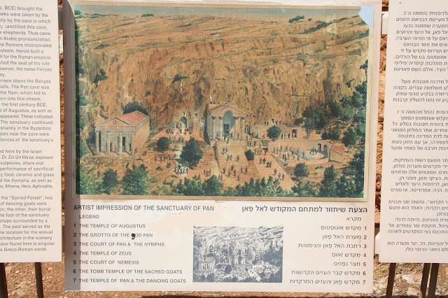
Cæsarea Philippi current goes by the name of Banias. Since Arabic doesn't have a letter P, the letter B serves as its substitute. Thus Banias could also be called Panias, which is appropriate since this Roman era town was centered on the cult of the god Pan. Banias sits at the southwest foot of Mt Hermon. The spring that flows forth out of the rocks at Banias is one of the three headwaters of the Jordan River.

The rocky cliffs that rise to the north of Cæsarea Philippi serve as a fitting back drop for Jesus' conversation with Peter (whose name means rock) and for referring to Peter and/or revelation and/or the gospel as the rock. More water flows in March (above) after the winter rains than in May (two above) when the dry summer season has begun.


 Banias Spring.
 Young figs hanging over the beginning of the Banias River.
 Statue of Peter holding the keys at Capernaum.

Mt. Hermon with two Druze villages below. The mountain sits at the southern end of the anti-Lebanon Mountain range and at the northern edge of the Golan Heights. It was part of Syria until the 1967 war when Israel conquered, occupied and then annexed the strategic territory. Israel has since built a ski area on the western end (left) mountain.
Read a recent Power Magazine article about skiing Mt. Hermon here: https://www.powder.com/stories/features/the-israeli-ski-community-on-the-worlds-most-militarized-border/
Some day I hope to ski Mt. Hermon. When he comes again I'm sure Jesus will be an avid skier.

Looking east across the Huleh Valley to Mt Hermon in the hazy distance. Photo taken from the mountains to the west of the Huleh Valley that form the border between Israel and Lebanon.
 The tall summit of Hermon peaks above the haze.

Nimrod's castle (an Arab fortress) sits astride the foot hills of Hermon. Banias is below at the base of the Mountain. The Huleh Valley is below. It is easy to see the strategic location of the Golan Heights when controlled by Syria as it loomed over Israel's Huleh valley. The Jordan River on the east side of the valley served as the Israel/Syrian border.
 Mt Meron from the north with the Arab village of Jish in the foreground.
 Mt. Tabor from the North. The Church of the Transfiguration can been seen on its summit.
 Looking northeast to Mt. Tabor from Nain.
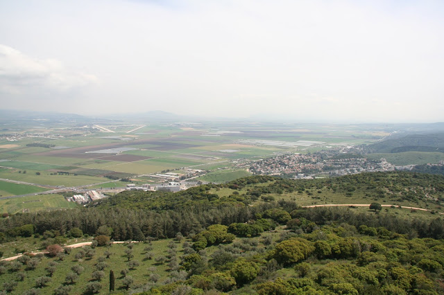
View from Mt Carmel across the Jezreel Valley (aka Valley of Armageddon) to Mt Tabor which rises (left of center) in the middle of the valley and is therefore set apart from other "mountains" (actually hills from a Utah perspective) in the Galilee.

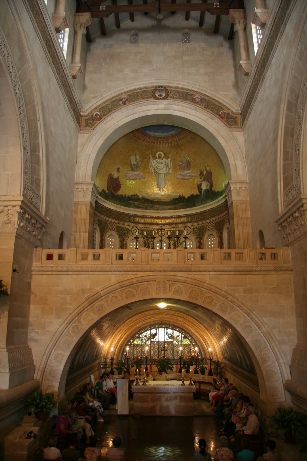
 Church of the Transfiguration (Franciscan) on the eastern edge of the summit of Mt Tabor.
 Jesus, Moses, Elijah, Peter, James and John.


2 He answered and said unto them, When it is evening, ye say, It will be fair weather: for the sky is red.
3 And in the morning, It will be foul weather to day: for the sky is red and lowring. O ye hypocrites, ye can discern the face of the sky; but can ye not discern the signs of the times?


13 ¶ When Jesus came into the coasts of Cæsarea Philippi, he asked his disciples, saying, Whom do men say that I the Son of man am?
14 And they said, Some say that thou art John the Baptist: some, Elias; and others, Jeremias, or one of the prophets.
15 He saith unto them, But whom say ye that I am?
16 And Simon Peter answered and said, Thou art the Christ, the Son of the living God.
17 And Jesus answered and said unto him, Blessed art thou, Simon Bar-jona: for flesh and blood hath not revealed it unto thee, but my Father which is in heaven.
18 And I say also unto thee, That thou art Peter, and upon this rock I will build my church; and the gates of hell shall not prevail against it.

Cæsarea Philippi current goes by the name of Banias. Since Arabic doesn't have a letter P, the letter B serves as its substitute. Thus Banias could also be called Panias, which is appropriate since this Roman era town was centered on the cult of the god Pan. Banias sits at the southwest foot of Mt Hermon. The spring that flows forth out of the rocks at Banias is one of the three headwaters of the Jordan River.

The rocky cliffs that rise to the north of Cæsarea Philippi serve as a fitting back drop for Jesus' conversation with Peter (whose name means rock) and for referring to Peter and/or revelation and/or the gospel as the rock. More water flows in March (above) after the winter rains than in May (two above) when the dry summer season has begun.


19 And I will give unto thee the keys of the kingdom of heaven: and whatsoever thou shalt bind on earth shall be bound in heaven: and whatsoever thou shalt loose on earth shall be loosed in heaven.

Matthew 17:
1 And after six days Jesus taketh Peter, James, and John his brother, and bringeth them up into an high mountain apart,
2 And was transfigured before them: and his face did shine as the sun, and his raiment was white as the light.
3 And, behold, there appeared unto them Moses and Elias talking with him.
4 Then
answered Peter, and said unto Jesus, Lord, it is good for us to be
here: if thou wilt, let us make here three tabernacles; one for thee,
and one for Moses, and one for Elias.
5 While he yet spake, behold, a bright cloud overshadowed them: and behold a voice out of the cloud, which said, This is my beloved Son, in whom I am well pleased; hear ye him.

 Source: https://www.casualenglishbible.com/casual-english-bible-maps-luke/

There are three traditional sites for the "high mountain apart." All fit the description. Mt. Hermon (#2 in the far north of the above map) (9,232 ft) rises above Caeserea Philippi which makes it an easy climb if the chronology in Matthew 16-17 is correct with the transfiguration coming right after the rock conversation between Jesus and Peter. Mt. Tabor (#2 in the center of the map) (1,886 ft) is a few hour walk from Nazareth and is very much a mountain set apart. It is easy to imagine that Jesus would have been very familiar with this mountain given his many years in Nazareth. Latter-day Saints from Apostles down to paltry pilgrims on a ten day tour to the Holy Land love to debate backed with quotes from church leaders whether Hermon or Tabor is the correct mount. Mt Meron (3,963 ft) in the western Galilee is also a high mountain set apart that some consider a likely candidate.


Mt. Hermon with two Druze villages below. The mountain sits at the southern end of the anti-Lebanon Mountain range and at the northern edge of the Golan Heights. It was part of Syria until the 1967 war when Israel conquered, occupied and then annexed the strategic territory. Israel has since built a ski area on the western end (left) mountain.
Read a recent Power Magazine article about skiing Mt. Hermon here: https://www.powder.com/stories/features/the-israeli-ski-community-on-the-worlds-most-militarized-border/
Some day I hope to ski Mt. Hermon. When he comes again I'm sure Jesus will be an avid skier.

Looking east across the Huleh Valley to Mt Hermon in the hazy distance. Photo taken from the mountains to the west of the Huleh Valley that form the border between Israel and Lebanon.


Nimrod's castle (an Arab fortress) sits astride the foot hills of Hermon. Banias is below at the base of the Mountain. The Huleh Valley is below. It is easy to see the strategic location of the Golan Heights when controlled by Syria as it loomed over Israel's Huleh valley. The Jordan River on the east side of the valley served as the Israel/Syrian border.


View from Mt Carmel across the Jezreel Valley (aka Valley of Armageddon) to Mt Tabor which rises (left of center) in the middle of the valley and is therefore set apart from other "mountains" (actually hills from a Utah perspective) in the Galilee.

From Mt Carmel with the hills of the lower Galilee where Nazareth is located (center) and Mt Tabor (right).


No comments:
Post a Comment